航运要塞是国际航海路线上的必经狭窄通道,是全球能源安全的重要组成部分。一旦海峡发生关闭,油轮可能被迫绕行其他路线,增加航行时间与成本,使原油价格发生大幅波动。
本报告主要介绍了全球石油海运流向及主要航运要塞。位于中东产油区波斯湾的霍尔木兹海峡,以及位于亚洲消费区的连接印度洋和太平洋的马六甲海峡是目前全球石油流量最大的海峡。
一、石油海运流向
全球原油海运主要流向,以中东、西非、南美为主的产油区,运往美国、欧洲、以及中国为代表的亚太地区。
1)最大海运流量来自波斯湾的中东原油,经由霍尔木兹海峡出至阿拉伯海,向东去往印度或过马六甲海峡运往中日韩;向西经由曼德海峡过苏伊士运河,或绕好望角运往欧洲或美湾/美东海岸。
2)西非原油过好望角至东亚,或经大西洋至欧洲或北美;北非过苏伊士运河至亚洲。
3)俄罗斯向西经苏伊士运河至亚洲;向东过日本海至中日韩。
4)南北美东岸过大西洋经好望角至东亚国家,西岸过太平洋至亚洲。另外还有南美-北美、东南亚-东亚、地中海-北海,以及西非-西欧、西非-北美、西欧-北美等相对中短途区域间航线。
二、主要油轮分类
目前全球原油及成品油轮分类体系主要依据平均运费指数(AFRA,Average Freight Rate Assessment)标准。该体系六十年前由皇家壳牌石油公司首次开发,通过标准化体系对油轮运费进行评估。主要可以分为以下几类:
通用型(GP,General Purpose)和中型(MR,Medium Range)油轮:通常用于较短距离内的成品油运输,如欧洲到美国东海岸、东南亚至南亚、波罗的海至美国等。 这种油轮船型较小,全球各地的大多数港口均可停泊。GP油轮可以装载7万桶和19万桶汽油,MR油轮可运载19-35万桶汽油。
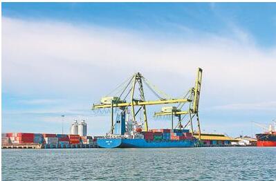
大型油轮(LR,Long Range):最常见的油轮,可同时运输原油和成品油,能够适应大部分油港进行装卸。 LR1型油轮可装运35-62万桶汽油,或31-55万桶轻质原油。阿芙拉型船(Aframax)结余LR1型和LR2型之间。
巨型油轮(VLCC)和超级油轮(ULCC)是目前国际长距离运输的主要油轮,运费相对低廉。一艘VLCC可装运约190-220万桶轻质原油。另外还有专为通过巴拿马运河设计的巴拿马型船(Panamax),及为苏伊士运河设计的苏伊士型船(Suezmax)。
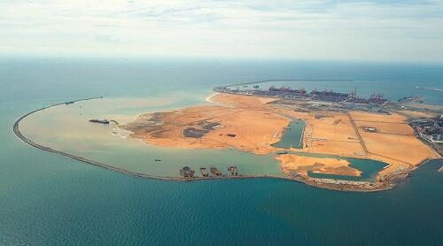
三、全球航运要塞
1.霍尔木兹海峡(Strait of Hormuz)
霍尔木兹海峡位于阿曼与伊朗之间,连接波斯湾与阿拉伯海。霍尔木兹海峡是世界上最重要的石油枢纽,2015年石油运输量约为1700万桶/日,占全球总量30%。2016年流量增加至创纪录的1850万桶/日。EIA估计通过海峡的原油约80%运往亚洲,出口至中国、日本、印度、韩国和新加坡等国。
霍尔木兹海峡最窄处只有21英里宽,其中船只可穿过的最窄航段宽2英里。霍尔木兹海峡的深度和宽度都足以容纳世界上最大的油轮,每年通过该海峡的油轮有三分之二载重量超过15万吨。
绕行管道
大多数可绕行霍尔木兹海峡的管道都暂未运营,目前只有沙特阿拉伯和阿联酋拥有绕行能力。截至2016年底,两国合计可用原油管道运量约为660万桶/日,闲置运能约为390万桶/日。
沙特的东-西石油管道(Petroline)全长746英里,始于布盖格(Abqaiq),横穿沙特,输送原油到红海。Petroline由两条管线组成,总运力约480万桶/日。其中一条56英寸的管道的运力为300万桶/日;另一条48英寸管道由天然气管道改造而成。2016年,沙特阿美公司宣布将东-西石油管道运能扩大至700万桶/日,预计计划在2018年底完成。但目前为止几乎没有进展。
阿联酋的阿布扎比原油管道运能为150万桶/日,从哈布汉(Habshan)运往阿曼湾的富查伊拉港(Fujairah),从而可以直接绕过霍尔木兹海峡。政府计划将这条管道的输油能力提高到180万桶/日。
其他暂不可用的绕行管道
沙特还有另外两条管道与Petroline管道并行,可绕过霍尔木兹海峡,但目前都没有额外输油能力。其中一条为伊拉克-沙特管道(IPSA,IraqiPipeline in Saudi Arabia),长48英寸,于1989年建成。1990年1月伊拉克开始使用该管道出口原油,输运量达165万桶/日。同年8月伊拉克入侵科威特后,沙特阿拉伯就关闭了该管道,管道仅仅运行了七个月。2001年6月,作为伊拉克的债务赔偿,沙特夺回IPSA所有权,并将其改造用于运送天然气。
其他管道,如从沙特阿拉伯的Qaisumah到黎巴嫩的Sidon的跨阿拉伯管道、伊拉克与土耳其之间的战略石油管道,由于战争破坏或者政治分歧,已经停止使用。这些管道重新投入使用前需要大量修复工作。如果霍尔木兹海峡封锁,汽运也可以缓解部分运输压力。
2.马六甲海峡(Strait of Malacca)
位于印度尼西亚、马来西亚、新加坡之间的马六甲海峡将印度洋和中国南海、太平洋连接起来。马六甲海峡是中东运往中日韩等亚洲消费市场最短的海上路线。2016年马六甲海峡运量为1600万桶/日,继续保持第二大航运要塞的地位。其中85%-90%为原油,其余为成品油。
马六甲海峡在新加坡附近最窄处只有1.7公里宽,油船碰撞、搁浅或泄漏都有可能发生。 据国际海事局报告,2015年马六甲海峡海盗劫持及偷窃事件明显增加。如果马六甲海峡被封锁,世界上近一半油轮都需要在印度尼西亚群岛周围改变航路,例如穿过印度尼西亚的巴厘岛和龙目岛之间的龙目海峡,或通过爪哇和苏门答腊间的巽他海峡。绕行将降低全球输油能力,增加运输成本,影响原油价格。
为缓解对马六甲海峡依赖,增加我国石油供应安全,中缅油气管道投入运行。管道于2013年开始供气,2015年首次输油,2017年重新开通,由瑞丽入境供应云南石化。中缅管道是继中哈原油管道、中亚天然气管道和中俄原油管道后又一条重要能源进口通道。
3.苏伊士运河(SuezCanal)/萨米德管道(SUMED Pipeline)
苏伊士运河和萨米德管道是中东石油和天然气出口到欧洲和北美的战略路线。2016年总流量约为550万桶/日,同比增加10万桶/天;占全球石油海运量的9%。
苏伊士运河
苏伊士运河位于埃及,连接红海与地中海。 2016年,石油和液化天然气分别占苏伊士货物总量的17%和6%。苏伊士运河不能通过VLCC和ULCC油轮,Suezmax是可以通过苏伊士运河的最大油船。2010年,苏伊士运河管理局将运河深度扩展至到66英尺,以满足60%以上的油轮过境需求。此外近93%的散货船和100%的集装箱船已能顺利通过苏伊士运河。
2016年苏伊士运河原油和成品油双向流量约为390万桶/日。北向流量240万桶/日,同比增加约30万桶/日,主要由于伊拉克和沙特对欧洲原油出口的增加;南向流向150万桶/日,2009年来首次同比下滑,主要来自俄罗斯到亚洲出口的下降。北向原油84%来自于波斯湾国家(沙特、伊拉克、科威特、阿联酋、伊朗、阿曼、卡塔尔、巴林);78%运往欧洲,14%运往北美。南向原油俄罗斯最多(17%),其次是土耳其(15%)、荷兰(11%)、北非(阿尔及利亚和利比亚,12%);主要出口至亚洲国家,新加坡、中国、印度占总量的50%以上。
萨米德管道
萨米德管道从红海经过埃及将原油运送到地中海。管道起始于红海埃因苏赫纳终端(Ain Sukhna),终于地中海的西迪基里尔终端(Sidi Kerir),全长200英里,总运力为234万桶/日。管道由阿拉伯石油管道公司持有,阿拉伯石油管道公司由埃及石油公司(50%),沙特石油公司(15%),阿布扎比国际石油投资公司(15%),多家科威特公司(15%)和卡塔尔石油公司(5%)合资组建。2016年萨米德管道流量约160万桶/日,与2015年持平。
如果船只无法穿过苏伊士运河,萨米德管道便是将原油从红海运送至地中海的唯一替代途径。苏伊士运河和萨米德管道同时关闭将迫使油轮绕行非洲南端好望角,使沙特到美国的运距增加约2,700英里,航程增加8-10天;到欧洲航程则增加15天左右。
通过苏伊士运河的VLCC也可使用萨米德管道进行驳运。因苏伊士运河深度不足以通过满载VLCC,因此需要在Ain Sukhna码头卸载部分原油,以减轻重量和吃水深度。通过运河后在萨米德管道另一端的Sidi Kerir码头重新装运之前卸载的原油。
4.曼德海峡(Babel-Mandeb)
曼德海峡是非洲和中东之间的交通要道,是地中海和印度洋之间的战略纽带。海峡位于也门、吉布提和厄立特里亚之间,将红海和亚丁湾,阿拉伯海连接起来。大部分来自波斯湾通过苏伊士运河和萨米德输油管道的油轮也会通过曼德海峡。2016年原油和成品油流量约为480万桶/日,主要目的地为欧洲、美国和亚洲。
曼德海峡最窄处只有18英里,仅能容纳两条两英里宽航道。若关闭曼德海峡,来自波斯湾的油轮无法北上通过苏伊士运河和萨米德管道,从欧洲和北非南下通往亚洲的油轮也无法通过苏伊士运河;均需从非洲南端绕行,增加运输时间和成本。
5.土耳其海峡(TurkishStraits)
土耳其海峡包括博斯普鲁斯海峡(Bosporus)和达达尼尔海峡(Dardanelles),是欧洲和亚洲的分界线。博斯普鲁斯海峡长17英里,是沟通黑海和马尔马拉海的狭窄水道。达达尼尔海峡长40英里,是马尔马拉海和爱琴海、地中海连接的要冲。这两条水道都位于土耳其,是俄罗斯和包括阿塞拜疆和哈萨克斯坦在内的里海地区国家向欧洲出口的主要海运路线之一。2016年原油和成品油流量约240万桶/日,其中80%是原油。
在2004年顶峰时期,土耳其海峡运量曾超过340万桶/日。自2005年开始,俄罗斯原油出口逐渐由黑海转移至波罗的海,海峡运量开始下降。但随后阿塞拜疆和哈萨克斯坦的出口增加,导致土耳其海峡的货运量增加,但增长并没有持续下去。土耳其海峡在过去五年中的运输量稳步下降,从2011年的290万桶/日缩减到2016年的240万桶/日。未来预计随着哈萨克斯坦卡沙甘油田原油产量的增加,土耳其海峡出口运量可能会有所增加。
土耳其海峡最窄处只有半英里宽,每年有大约4.8万艘船只过海,是世界上最繁忙和最难航行的水道之一。尽管土耳其声称对有权对海峡的环境和安全问题进行监管,但和平时期商业船只均可自由通过海峡。
巴拿马运河是连接太平洋与大西洋的重要航运要道。运河全长50英里,位于大陆分界线的库莱布拉峡谷(Culebra Cut)最窄处仅110英尺。2016年有超过1.3万艘船只途经此处,载货量2.04亿吨。其中67%来自或前往美国,19%来自与中国的往来贸易。
巴拿马运河并非全球石油运输最重要航道,2015年石油运量仅占全球总运量的1.7%。2016年石油运量为92万桶/日,其中84万桶为成品油,其余为原油。汽油运量(77.5万桶/日)的84%均为由大西洋至太平洋的南向运输。
巴拿马运河的替代航线是位于南美洲南端的麦哲伦海峡(the Straits of Magellan)、合恩角海峡(Cape Horn)和德雷克海峡(Drake Passage)。这些海峡会增加8000英里的运距,使运输时间和成本大幅增加。
大型油轮如ULCC尺寸约为运河最大容量的五倍。为改善通航能力,巴拿马运河管理局于2016年6月完成自1914年运河竣工以来的首次扩建计划。巴拿马运河原有两条航道,扩建后将增加第三条航道。可通行船只由原来的巴拿马型船(30-50万桶成品油)扩大至新巴拿马型船(40-60万桶成品油)。航道依旧不能通过VLCC船,对石油运输改善不大。更有利从美国运往亚洲的丙烷和HGL出口。
由巴拿马石油公司(PTP)经营的跨巴拿马管道(TPP,Trans-PanamaPipeline)是绕行巴拿马运河的主要管道。管道于1982年开始运营,最初目的是将阿拉斯加北坡的原油运往加勒比海和美湾地区的炼厂。2010年8月,管道完成反向改造,将石油从加勒比海运往太平洋。2012年BP和PTP签署了七年的储运协议,允许BP租赁位于加勒比和太平洋沿岸的仓储设施,并使用TPP管道将原油运送到美国西海岸炼厂。2017年初壳牌公司也签署了一项为期三年的租赁协议,以获得仓储、转运、管道、码头。2016年有11万桶原油通过管道输送到了查科阿苏尔港。
7.丹麦海峡(DanishStraits)
丹麦海峡连接波罗的海和北海,是俄罗斯石油海运出口到欧洲的重要途径。2016年日均约有320万桶石油通过丹麦海峡。自2005年开放Primorsk港口后,俄罗斯将大部分原油出口转移到波罗的海港口。2011年,Primorsk港口石油出口占丹麦海峡所有出口货物的近一半,2016年该比例下降到32%。部分来自挪威和英国的石油也从2016年开始向东流向斯堪的纳维亚市场。
8.好望角(Capeof Good Hope)
位于非洲南部的好望角是全球油轮运输的重要中转站。EIA估计2016年每天约有580万吨海运原油通过好望角。其中430万桶原油向东运输,主要来自非洲(220万桶/日)和南美(160万桶/日,流向亚洲市场(410万桶/日)。 西向运输则来自中东(150万桶/日),运往美国(75%)和欧洲(12%)。
好望角也是通过亚丁湾、曼德海峡和苏伊士运河向西行驶的替代航线,但绕行好望角的时间和成本都会相应增加。据美国交通运输部测算,若关闭苏伊士运河和SUMED输油管道,从沙特运向美国的油轮绕行好望角会增加约2700英里的路程。到达欧洲的时间将增加15天,到达美国的时间增加8-10天。
Shipping is an important mode of transportation for global oil trade. According to the 2017 BP energy statistical review, global oil production in 2016 was 92.15 million BPD and trade volume was 65.45 million BPD. The EIA estimates that 58.9m b/d of seaborne oil shipped in 2015 accounted for 61% of total production.
Shipping fortress is an important part of global energy security. In the event of a closure, tankers could be forced to take other routes, adding to voyage times and costs and making crude prices volatile.
This report focuses on the global oil shipping flows and major shipping hubs. The strait of hormuz in the Persian gulf, in the Middle East's oil-producing region, and the strait of malacca, which links the Indian and Pacific oceans in Asia's consumer region, are the world's largest oil flows.
I. direction of oil shipping
Global crude oil shipping flows mainly to the oil producing regions in the Middle East, west Africa and South America, and to the asia-pacific region represented by the United States, Europe and China.
1) the largest shipping flow of Middle East crude oil from the Persian gulf, through the strait of hormuz to the Arabian sea, east to India or through the strait of malacca to China, Japan and Korea; To the west via the mender strait through the Suez Canal, or around the cape of good hope for Europe or the gulf/east coast.
2) west African crude oil from the cape of good hope to east Asia, or via the Atlantic to Europe or North America; North Africa reaches Asia via the Suez Canal.
3) Russia goes west via the Suez Canal to Asia; East over the sea of Japan to China, Japan and South Korea.
4) the east coast of north and South America is from the Atlantic ocean to east Asian countries via the cape of good hope, and the west coast is from the Pacific Ocean to Asia. In addition, there are South America - North America, southeast Asia - east Asia, Mediterranean - north sea, and west Africa - Western Europe, west Africa - North America, west Europe - North America and other relatively short - and medium-distance regional routes.
Classification of major tankers
At present, the classification system of crude oil and refined oil products is mainly based on the standard of AFRA (Average Freight Rate Assessment). The system, first developed by royal Dutch shell 60 years ago, USES a standardised system to assess tanker rates. It can be divided into the following categories:
GP, General Purpose and MR, Medium Range tankers: usually used for the transportation of refined oil within a short distance, such as Europe to the east coast of the United States, southeast Asia to South Asia, the Baltic sea to the United States, etc. The tanker is small and can berth in most ports around the world. GP tankers can carry 70,000 barrels and 190,000 barrels of gasoline, and MR tankers can carry 190,000 to 350,000 barrels of gasoline.
Large tanker (LR, Long Range) : the most common tanker capable of transporting both crude and refined oil at the same time and capable of handling most oil ports. The LR1 tanker can carry 350,000 to 620,000 barrels of gasoline or 310,000 to 550,000 barrels of light crude oil. Aframax balance between LR1 and LR2.
Supertankers (VLCC) and supertankers (ULCC) are the main tankers for international long-distance transportation at a relatively low cost. One VLCC can carry about 1.9 to 2.2 million barrels of light crude oil. There are also Panamax ships designed for passing through the panama canal and Suezmax ships designed for the Suez Canal.
Third, the global shipping fortress
1. Strait of Hormuz
The strait of hormuz, between Oman and Iran, connects the Persian gulf to the Arabian sea. The strait of hormuz is the world's most important oil hub, carrying about 17 million barrels of oil per day in 2015, or 30 percent of the global total. Flows increased to a record 18.5m b/d in 2016. The EIA estimates that about 80% of the crude oil that passes through the strait is shipped to Asia, where it is exported to countries such as China, Japan, India, South Korea and Singapore.
The strait of hormuz is only 21 miles wide at its narrowest point, of which the narrowest section for ships is two miles wide. The strait of hormuz is deep and wide enough to hold the world's largest oil tankers, two-thirds of which pass more than 150,000 tonnes a year.
Round pipe
Most of the pipelines that bypass the strait of hormuz are not yet operational, with only Saudi Arabia and the united Arab emirates having the ability to do so. By the end of 2016, the two countries had about 6.6 million barrels per day of pipeline capacity available and 3.9 million barrels per day of idle capacity.
Saudi Arabia's 746 - mile east - west Petroline pipeline starts at Abqaiq and travels across the kingdom carrying crude oil to the red sea. Petroline consists of two pipelines with a total capacity of about 4.8 million b/d. One of the 56-inch pipes has a capacity of 3 million b/d; The other 48-inch pipeline is a natural gas pipeline. In 2016, Saudi aramco announced the expansion of the east-west pipeline to 7 million b/d, which is expected to be completed by the end of 2018. But so far there has been little progress.
The uae's ABU dhabi crude pipeline, with capacity of 1.5m b/d, will carry from Habshan to Fujairah on the gulf of Oman, allowing it to bypass the strait of hormuz directly. The government plans to increase the pipeline's capacity to 1.8 million barrels a day.
Other detour pipes temporarily unavailable
Saudi Arabia has two other pipelines running alongside Petroline to bypass the strait of hormuz, but neither has additional capacity. One, the 48-inch IPSA, IraqiPipeline in Saudi Arabia, was completed in 1989. Iraq began exporting crude oil through the pipeline in January 1990, carrying 1.65 million b/d. Saudi Arabia shut down the pipeline after Iraq's invasion of Kuwait in August that year, and it lasted only seven months. In June 2001, as compensation for Iraq's debts, Saudi Arabia regained ownership of IPSA and converted it to deliver gas.
Other pipelines, such as the trans-arab pipeline from Qaisumah in Saudi Arabia to Sidon in Lebanon, and the strategic oil pipeline between Iraq and Turkey, have been suspended because of war disruptions or political disagreements. Extensive repairs are needed before the pipes can be brought back into service. If the strait of hormuz were closed, steam transport could relieve some of the pressure.
2. Strait of Malacca
The strait of malacca between Indonesia, Malaysia and Singapore connects the Indian Ocean with the south China sea and Pacific Ocean. The strait of malacca is the shortest sea route from the Middle East to Asian consumer markets such as China, Japan and South Korea. In 2016, the strait of malacca handled 16 million b/d, maintaining its position as the second largest shipping stronghold. Of this, 85-90% is crude oil and the rest is refined oil.
The strait of malacca is only 1.7 kilometers wide at its narrowest point near Singapore, and collisions, strandings or leaks can occur. Hijackings and thefts by pirates in the straits of malacca increased significantly in 2015, according to the international maritime bureau. If the strait of malacca were blocked, nearly half the world's oil tankers would have to change course around the Indonesian islands, for example through the lombok strait between Bali and lombok in Indonesia, or through the sunda strait between Java and Sumatra. Detour will reduce global capacity, increase transportation costs and affect crude oil prices.
In order to ease the dependence on the strait of malacca and increase the security of China's oil supply, the china-myanmar oil and gas pipeline has been put into operation. The pipeline began to supply gas in 2013, first transported oil in 2015, and reopened in 2017, with ruili supplying yunnan petrochemical. The china-myanmar pipeline is another important energy import channel following the china-kazakhstan crude oil pipeline, the central Asia natural gas pipeline and the china-russia crude oil pipeline.
3. SuezCanal/SUMED Pipeline
The Suez Canal and the samid pipeline are strategic routes for middle eastern oil and gas exports to Europe and North America. The total flow in 2016 was about 5.5 million b/d, an increase of 100,000 b/d; It accounts for 9% of the world's seaborne oil traffic.
Suez Canal
The Suez Canal is located in Egypt and connects the red sea to the Mediterranean Sea. In 2016, oil and liquefied natural gas accounted for 17% and 6% of suez's total cargo, respectively. Suezmax is the largest tanker that can pass through the Suez Canal, which cannot pass VLCC or ULCC tankers. In 2010, the Suez Canal authority expanded the canal to a depth of 66 feet to meet more than 60 percent of tanker demand. In addition, nearly 93 percent of bulk carriers and 100 percent of container ships already pass through the Suez Canal.
The two-way flow of crude and refined oil through the Suez Canal was about 3.9 million BPD in 2016. Northbound flow of 2.4 million b/d, an increase of about 300,000 b/d, mainly due to increased crude oil exports from Iraq and Saudi Arabia to Europe; Southbound flows of 1.5 million b/d fell year-on-year for the first time since 2009, mainly due to a drop in Russian exports to Asia. Eighty-four percent of northbound crude comes from the gulf states (Saudi Arabia, Iraq, Kuwait, united Arab emirates, Iran, Oman, Qatar, bahrain). 78% went to Europe and 14% to North America. South to Russia (17%), followed by Turkey (15%), the Netherlands (11%), north Africa (Algeria and Libya, 12%). The main exports to Asian countries, Singapore, China, India accounted for more than 50% of the total.
The samid pipeline
The samid pipeline carries crude oil from the red sea to the Mediterranean Sea via Egypt. Starting at the Ain Sukhna terminal in the red sea and ending at Sidi Kerir in the Mediterranean, the 200-mile pipeline has a total capacity of 2.34 million b/d. The pipeline is owned by aramco, which is a joint venture between egyptoil (50%), Saudi aramco (15%), ABU dhabi international petroleum investment company (15%), a number of Kuwaiti companies (15%) and Qatar petroleum (5%). About 1.6 million b/d flowed through the samid pipeline in 2016, the same as in 2015.
If ships cannot cross the Suez Canal, the samid pipeline is the only alternative route to carry crude oil from the red sea to the Mediterranean. The simultaneous closure of the Suez Canal and the samid pipeline will force tankers to circle the cape of good hope, the southern tip of Africa, adding about 2,700 miles to the saudi-u.s. route and eight to 10 days to the voyage. The voyage to Europe adds about 15 days.
The VLCC through the Suez Canal can also be transferred using the samid pipeline. Since the Suez Canal is not deep enough to carry a full load of VLCC, some crude oil needs to be unloaded at the Ain Sukhna terminal to reduce weight and draft depth. After passing through the canal, crude oil unloaded before is reloaded at the Sidi Kerir terminal at the other end of the samid pipeline.
4. Babel-mandeb
The strait of mandeb is a major transportation route between Africa and the Middle East and a strategic link between the Mediterranean and the Indian Ocean. Located between yemen, djibouti and eritrea, the strait connects the red sea with the gulf of Aden and the Arabian sea. Most of the oil tankers from the Persian gulf that pass through the Suez Canal and the samid pipeline also pass through the mander strait. Crude and refined oil flows in 2016 were about 4.8 million BPD, with major destinations in Europe, the United States and Asia.
At its narrowest point, the strait of mander is only 18 miles long, accommodating only two two-mile wide lanes. Closing the mandeb strait would prevent tankers from the Persian gulf from going north through the Suez Canal and the samid pipeline, or from Europe and north Africa south to Asia. All require detour from the southern tip of Africa, increasing transportation time and cost.
5. TurkishStraits
The Turkish straits, which include the Bosporus and Dardanelles, divide Europe and Asia. The bosporus is 17 miles long, a narrow waterway that connects the black and marmara seas. The dardanelles is a 40-mile waterway that connects the sea of marmara with the Aegean and Mediterranean seas. The two waterways, both in Turkey, are one of the main shipping routes for Russia and Caspian countries, including azerbaijan and kazakhstan, to Europe. About 2.4 million BPD of crude and refined oil flowed in 2016, 80% of which was crude oil.
At its peak in 2004, the Turkish channel handled more than 3.4 million b/d. Since 2005, Russian crude oil exports have gradually shifted from the black sea to the Baltic sea, and the volume of the strait began to decline. But the subsequent increase in exports from azerbaijan and kazakhstan led to an increase in cargo traffic across the Turkish straits, which did not last. Traffic through the Turkish channel has declined steadily over the past five years, from 2.9 million b/d in 2011 to 2.4 million b/d in 2016. In the future, with the increase of crude oil production from kazakhstan's kashagan oil field, the Turkish channel export volume is expected to increase.
Only half a mile wide at its narrowest point, the Turkish strait is one of the busiest and most difficult waterways in the world, with some 48,000 ships crossing the sea each year. Although Turkey claims the right to regulate environmental and safety issues in the strait, commercial vessels are free to cross in peacetime.
The panama canal is an important shipping route connecting the Pacific and Atlantic oceans. The canal is 50 miles long and only 110 feet at its narrowest point, the Culebra Cut, at the continental border. More than 13,000 ships passed through in 2016, carrying 204 million tons of cargo. Of those, 67 percent came from or traveled to the United States and 19 percent from trade with China.
The panama canal is not the world's most important shipping route for oil, accounting for just 1.7 per cent of global traffic in 2015. The volume of oil shipped in 2016 was 920,000 b/d, of which 840,000 b/d was refined oil and the rest crude oil. Eighty-four percent of gasoline shipments (775,000 b/d) were shipped south from the Atlantic to the Pacific Ocean.
Alternative routes to the panama canal are the Straits of Magellan, Cape Horn and Drake Passage at the southern tip of South America. These straits will add 8,000 miles to the shipping distance, greatly increasing the time and cost of transportation.
Large tankers such as ULCC are about five times the size of the canal's maximum capacity. In June 2016, the panama canal authority completed its first expansion since the completion of the canal in 1914 to improve navigation. The expansion of the panama canal, which already has two shipping lanes, will add a third. Passable vessels were expanded from the original panamax vessels (300,000-500,000 barrels of refined oil) to new panamax vessels (400,000-600,000 barrels of refined oil). The channel still cannot pass through the VLCC ship, the oil transport is not much improved. Propane and HGL exports from the United States to Asia are more favorable.
The Trans PanamaPipeline (TPP, trans-panamapipeline), operated by the Panamanian oil company (PTP), is the main route around the panama canal. The pipeline, which began operations in 1982, was originally intended to carry crude oil from Alaska's north slope to refineries in the Caribbean and gulf of America. In August 2010, the pipeline was reverse-engineered to carry oil from the Caribbean to the Pacific Ocean. BP and PTP signed a seven-year storage and transportation agreement in 2012, allowing BP to lease storage facilities along the Caribbean and Pacific coasts and use the TPP pipeline to ship crude to refineries on the U.S. west coast. Shell also signed a three-year lease in early 2017 to secure storage, transshipment, pipelines and terminals. In 2016, 110,000 barrels of oil were piped to the port of chaco azur.
7. The DanishStraits
The Danish strait, which links the Baltic and north seas, is an important route for Russian oil shipments to Europe. About 3.2 million barrels of oil a day passed through the Danish strait in 2016. Since opening the port of Primorsk in 2005, Russia has shifted most of its crude exports to Baltic ports. In 2011, Primorsk's oil exports accounted for nearly half of all goods exported through the Danish channel, and in 2016 that share fell to 32%. Some oil from Norway and the UK also started flowing east to Scandinavian markets in 2016.
8. Capeof Good Hope
The cape of good hope in southern Africa is an important transit point for oil tankers worldwide. The EIA estimates that about 5.8 million tons of seaborne crude oil passed through the cape every day in 2016. Of this, 4.3 million b/d was shipped east, mainly from Africa (2.2 million b/d) and South America (1.6 million b/d) to the Asian market (4.1 million b/d). Westbound shipments came from the Middle East (1.5 million b/d) and were destined for the United States (75%) and Europe (12%).
The cape of good hope is also an alternative route westward through the gulf of Aden, the bab al-mandeb strait and the Suez Canal, but the time and cost of circumnavigating it increases accordingly. America's department of transportation reckons that closing the Suez Canal and the SUMED pipeline would add about 2,700 miles to the journey of tankers from Saudi Arabia to the United States around the cape of good hope. It will take 15 more days to reach Europe and 8-10 more days to reach the United States.